Theme 1: CSD13 to CSD25
Policy CSD 13: Conservation Target Areas
3.92 Conservation Target Areas form a key part of the Nature Recovery Network core and recovery zones and the emerging LNRS. The Target Areas were identified to focus biodiversity restoration work at a landscape scale through the maintenance, restoration and creation of UK BAP priority habitats (habitats of principal importance for the conservation of biodiversity under Section 41 of the NERC Act). This is their principal aim. Addressing habitat fragmentation through the linking of sites to form strategic ecological networks can help species adapt to the impact of climate change and represent areas of greatest opportunity for strategic biodiversity improvement in the district. Development will be expected to contribute to the achievement of the targets and aims for habitats and species of the CTA through avoiding habitat damage/fragmentation and enhancing biodiversity.
3.93 Sixteen Conservation Target Areas lie wholly or partly within Cherwell District. General targets for maintenance, restoration and creation of habitats have been set for each area, to be achieved through a combination of biodiversity project work undertaken by a range of organisations, agri-environment schemes and biodiversity enhancements secured in association with development.
3.94 Biodiversity enhancements sought in association with development could include the restoration or maintenance of habitats through appropriate management, new habitat creation to link fragmented habitats, or a financial contribution towards biodiversity initiatives in the Conservation Target Area. Further guidance on the approach to be taken is being developed as part of the emerging Local Nature Recovery Strategy.
Policy CSD 13: Conservation Target Areas
Where development is proposed within or adjacent to a Conservation Target Area, biodiversity surveys and a report will be required to identify constraints and opportunities for biodiversity enhancement. Development that would have an adverse impact on the target habitats and species of a CTA or prevent its aims being achieved will not be permitted. Where there is potential for development, planning conditions or obligations will be used to secure biodiversity enhancement of the target habitats and species of the Conservation Target Area.
Policy CSD 14: Natural Capital and Ecosystem Services
3.95 One approach to understanding the value of the natural environment for people is through an approach known as ‘natural capital’ and identifying the ‘ecosystem services’ it provides. We recognise the value of natural capital assets in terms of the ecosystem services they provide and will ensure that this is taken into account in the consideration of planning applications so that the wider benefits of natural capital are delivered.
3.96 The Natural Capital Map of Oxfordshire (2021) presents the natural capital assets present in Cherwell, whilst Cherwell’s Natural Capital Assets report (2021) provides a preliminary register of natural capital assets present in the district. Where an environmental impact assessment is required, planning applications will be expected to provide an assessment of the long-term impacts of the proposed development on natural capital and ecosystem services to enhance the design of new buildings and spaces across the site.
Policy CSD 14: Natural Capital and Ecosystem Services
The Natural Capital Map of Oxfordshire will be expected to be used to inform the planning of development sites to ensure the protection of those areas with high value natural capital assets.
All new major development proposals will be supported by a natural capital assessment to demonstrate the impact of the development on the environment and any environmental net gain to be secured.
Policy CSD 15: Green and Blue Infrastructure
3.97 The district’s green and blue infrastructure network is made up of many features. These can include parks and gardens, natural and semi-natural green spaces, green and blue corridors (including cycleways, rights of way, canals and rivers), outdoor sports facilities, amenity green spaces, allotments, cemeteries/ churchyards, woodlands, green roofs and walls. Together, these assets offer a range of health and quality of life benefits for local communities and provide refuges for wildlife species inhabiting these environments. Establishing new linkages and reinforcing existing connections between these assets will often benefit the network as a whole.
3.98 Green and blue corridors consist of canals, rivers, woodland and hedgerows, together with public rights of way which offer routes for sustainable travel options as well as providing opportunities for wildlife migration. By enabling species to explore new habitats and by enhancing green and blue corridors; species can adapt more easily to habitat loss. Development proposals will be expected to retain and enhance existing green and blue corridors and maximise the opportunity to form new connections between existing green and blue infrastructure assets.
3.99 A draft Oxfordshire-wide Nature Recovery Network has been produced with a Local Nature Recovery Strategy emerging. This will identify key locations for biodiversity gain building on the principles of Conservation Target Areas to focus efforts on habitat restoration and enable wildlife species to move over wider areas.
3.100 Our Green and Blue Infrastructure Strategy (2022) provides guidance to developers and other stakeholders on how to integrate green and blue infrastructure enhancements into proposals. It also spatially represents the current Cherwell green and blue infrastructure network and provides recommendations to address challenges and opportunities to improve existing green and blue infrastructure provision.
Policy CSD 15: Green and Blue Infrastructure
The Council will require the protection and enhancement of sites that form part of the existing green and blue infrastructure (GBI) network and the improvement of sustainable connections between sites. The inclusion of meaningful and integrated GBI in development proposals will be required.
For major developments (see glossary), priority will be given to the role of GBI in responding to climate change, managing flood risk, protecting and enhancing heritage assets, supporting sustainable transport options, supporting biodiversity and the natural environment, and ensuring open space for sports and recreation is secured for the community.
All development will be required to demonstrate strategies to both protect and enhance existing GBI and to also incorporate new GBI in the design approach for each site. Where applicable, applicants will be expected to demonstrate:
i. How existing GBI identified on-site will be protected and incorporated into the layout, design and appearance of proposals;
ii. Where connection(s) proposed between existing and new GBI on-site can be established including identifying opportunities for connectivity with off-site GBI;
iii. How restored or re-created habitats can be accommodated within the proposed development and how biodiversity net gain can be achieved;
iv. How existing trees and hedgerows will be protected both during and after development and the opportunities for increasing tree cover through new planting;
v. How the existing and proposed built and natural landscape can be improved through the provision of GBI including for the preservation and enhancement of the historic environment;
vi. How GBI will be provided along movement corridors for all modes of transport on-site (including motorised and non-motorised means of travel);
vii. Where multi-functioning GBI can be achieved on-site, including to adapt and mitigate against climate change impacts, to protect and enhance biodiversity, manage flood risk, to improve air quality, and to promote health and well-being in the local community;
viii. How the appropriate use and permanence of the Green Belt will be maintained and enhanced by existing and new GBI on-site, and
ix. How existing and new GBI will be maintained and managed post development.
Off-site provision will only be allowed in exceptional circumstances and where it has been agreed that it will not be possible to provide on-site net biodiversity gains.
Policy CSD 16: Air Quality
3.101 Air pollution is caused by a variety of domestic, industrial and vehicular related sources and it is associated with directly causing adverse health impacts on physical and mental health some of which are a contributing factor in the onset of lung, heart and cancer conditions.
3.102 The Council is committed to working with partners to reducing the exposure of people in Cherwell to poor air quality in order to improve and maintain the health and wellbeing of the local communities within the District. As part of the Council's statutory duty, it produces an Air Quality Action Plan (AQAP) which details the actions that the Council will take in order to improve the air quality within the District.
3.103 Development proposals that are likely to have an impact on local air quality, including those in, or within relative proximity to, existing or potential Air Quality Management Areas (AQMAs) , or within relative proximity to the Oxford Meadows Special Area of Conservation (SAC) will need to assess any impact and demonstrate mitigation measures that are incorporated into the design specifically to minimise any impacts associated with air quality.
3.104 Where construction and sensitive development is proposed in areas of existing poor air quality and/or where it is deemed the proposals will have an impact on air quality, the applicant will be required to undertake and submit an air quality assessment and a Sustainable Construction Management Plan which details the impact and the proposed mitigation. It is recommended that the applicant undertakes pre application engagement with the relevant statutory consultees including the Council's Environmental Protection Team before submitting their planning application.
3.105 Applicants will be required to demonstrate that the development will minimise the impact on air quality, both during the construction period and throughout the lifetime of the completed development.
3.106 Mitigation measures will need to demonstrate how the proposal would make a positive contribution towards the aims of the Council’s latest Air Quality Action Plan and the Local Transport Plan.
3.107 Mitigation measures will be secured either through a negotiation on a scheme, or via the use of a planning condition/s and/or planning obligation/s depending on the scale and nature of the development and its associated impacts on air quality.
Policy CSD 16: Air Quality
All development proposals should be designed to be air quality neutral. The design and layout of a development should seek to improve air quality to protect the health and wellbeing of all end users.
Development proposals that are likely to have an impact on local air quality, including those in, or within relative proximity to, existing or potential Air Quality Management Areas (AQMAs) and those in, or within relative proximity to the Oxford Meadows Special Area of Conservation (SAC) will be required to provide appropriate design and related infrastructure mitigation measures to minimise any adverse impacts.
Where development is proposed in areas of existing poor air quality, or where development may impact the Oxford Meadows SAC, and/or where significant development is proposed, an air quality assessment and a Sustainable Construction Management Plan will normally be required. The Council will require applicants to demonstrate that the development will minimise the impact on air quality, both during construction and throughout the lifetime of the completed development.
Mitigation measures will need to demonstrate how the proposal/s would make a positive contribution towards the aims of the Council’s Air Quality Action Plan and the County Council's Local Transport Plan. Mitigation measures will be secured either through a negotiation on a scheme, or via the use of a planning condition/s and/or planning obligation depending on the scale and nature of the development and its associated impacts on air quality.

Policy CSD 17: Pollution and Noise
3.108 Pollution can be both visible and invisible and can take many forms including chemical, dust, light, noise, fumes, smell and vibration, all of which can have detrimental impacts on the environment and quality of life. Prolonged exposure to noise can cause permanent damage to health.
3.109 Any potentially adverse effects must be carefully considered in the assessment of any planning application and can be the basis for the refusal of a planning application if not adequately addressed. Developers are encouraged to have pre-application discussions with the Council to be advised on the specific requirements.
3.110 Assessments should:
- Identify the sensitive receptor(s) which may be affected by the proposed development, including residents, businesses, educational, health, leisure, community uses, land users and sensitive environmental and heritage assets
- Consider the potential for cumulative impacts with other existing or approved development including those that are under construction
- Demonstrate the measures which would be implemented to ensure adverse impacts would be avoided at source or, where this is not possible, outline the proposed management and mitigation measures to reduce effects to an acceptable level; and identify the significance of any residual effects.
3.111 Developers are expected to proactively monitor impacts and emissions to enable pollution related issues to be addressed swiftly. Close liaison with communities and those directly impacted can support this approach, enabling feedback and dialogue on the need for and effectiveness of any proposed or existing mitigation measures.
Policy CSD 17: Pollution and Noise
Development will not be permitted if it results in an unacceptable risk to public health or safety, the environment, general amenity or existing uses due to the potential of air pollution, noise nuisance, vibration, odour, light pollution, surface/ground water sources or land pollution.
In order to reduce, manage and mitigate noise to improve health and quality of life, residential and other development proposals should manage noise by:
i. Avoiding significant adverse noise impacts on health and wellbeing, quality of life and amenity including residential amenity;
ii. Mitigating and minimising the existing and potential adverse impacts of noise on, from, within, as a result of, or in the vicinity of new development without placing unreasonable restrictions on existing noise-generating uses;
iii. Separating new noise-sensitive development from major noise sources (such as road, rail, air transport and some types of industrial use, and some types of leisure and recreational uses) through the use of distance, screening, layout, orientation, uses and materials – in preference to sole reliance on sound insulation;
iv. Where it is not possible to achieve separation of noise-sensitive development and noise sources without undue impact on other sustainable development objectives, then any potential adverse effects should be controlled and mitigated through applying good acoustic design principles and design solutions including the use of appropriate materials; and
v. Promoting new technologies and improved practices to minimise noise at source, and on the transmission path from source to receptor.
Where the operation of an existing business or community facility could have a significant adverse effect on new development (including changes of use) in its vicinity, the applicant (or ‘agent of change’) will be required to provide suitable mitigation before the development has been completed. Development proposals that have not clearly demonstrated how noise and other nuisances will be minimised, mitigated and managed will not be permitted.
Policy CSD 18: Light Pollution
3.112 Light pollution mapping shows high levels of light pollution above Banbury, Bicester, Kidlington and Yarnton. However, there are still significant areas of the district with relatively low levels of light pollution.
3.113 Artificial lighting is necessary in many circumstances including for public safety, enabling nighttime activities including for leisure and recreation facilities and for activities related to airport operations. Yet artificial lighting also has the potential to harm local amenity and wildlife, whilst also undermining people’s enjoyment of the open countryside, areas of tranquillity and dark skies.
3.114 Careful location, positioning and design of lighting can minimise the above impacts. Lighting schemes should therefore use and follow best practice for the reduction of light pollution.
Policy CSD 18: Light Pollution
Development will be expected to avoid harmful light pollution to people and wildlife. Unnecessary light pollution which causes carbon emissions or detracts from the visual amenity of an area should also be avoided.
Proposals for any external lighting will need to demonstrate that:
i. The lighting is the minimum required for its intended use;
ii. Light pollution is minimised, and
iii. There is no unacceptable impact on residential amenity, adjacent land uses, the character and appearance of the landscape, nature conservation, or highway safety.
Policy CSD 19: Soils, Contaminated Land and Stability
3.115 Contaminated land is land that has been polluted with harmful substances that are causing or could cause:
a) significant harm to people, property or protected species
b) significant pollution of surface waters including lakes, rivers or groundwater
c) harm to people as a result of radioactivity
3.116 Cherwell District has a history of industrial and defence related land uses and we want to ensure that the impacts of these past and current land uses do not affect or harm the health of people, animals or the environment.
3.117 Any site which is potentially contaminated will be required to carry out a site investigation and agree a scheme of mitigation with us to ensure that contaminated land issues are considered at the planning application stage.
3.118 A verification report will be required through condition in order to provide confirmation that the remediation work has been undertaken properly in line with best practice.
3.119 The term ‘poor ground conditions’ referred to in Policy CSD 19 may include, but is not limited to the following:
- Poorly consolidated made ground and fill material
- Soft, weak and wet natural soils
- Areas of shallow mine-workings and mineshafts.
3.120 The principal factors influencing agricultural production are climate, site and soil. These factors together with the interactions between them form the basis for classifying land into one of five grades, where 1 describes land as excellent (land of high agricultural quality and potential) and 5 describes land as very poor (land of low agricultural quality and potential). Land falling outside of these scores is deemed to be ‘primarily in non-agricultural use’, or ‘land predominantly in urban use’. The NPPF defines Grades 1-3a as ‘best and most versatile’ and states that planning policies should recognise the economic and other benefits of best and most versatile land.
Policy CSD 19: Soils, Contaminated Land and Stability
Development will not be permitted where the land is contaminated and not capable of appropriate remediation without compromising development viability or the delivery of sustainable development.
For sites where land contamination is suspected, an adequate site investigation survey will need to be prepared (by a competent specialist person) to demonstrate that land contamination issues have been fully addressed or can be satisfactorily addressed through the development.
Development will not be permitted in locations where there are risks from land instability. Development within areas known or suspected to be at risk of slope instability or poor ground conditions will need to demonstrate the following:
i. Its structural integrity will not be compromised by slope instability;
ii. The development does not exacerbate any instability on the site or elsewhere;
iii. The development can tolerate ground conditions by special design, and
iv. There is long-term stability of any structure built on made, filled or mined ground.
For sites suspected of land instability, an adequate site investigation survey will need to be prepared (by a competent specialist person) to demonstrate that land instability issues will be fully addressed.
Policy CSD 20: Hazardous Substances
3.121 In considering proposals for development which may involve hazardous substances, we will need to be completely satisfied that the proposal will not constitute a hazard to our existing and future planned communities and/or the local environment. Similarly, existing consents will be an important consideration in the determination of sensitive uses such as housing.
3.122 Advice will be sought from the Control of Major Accident Hazards (COMAH) competent authority concerning off-site risks to the public arising from any proposed development which would introduce hazardous substances, or of existing hazardous installations to proposed developments. Careful consideration will be given to the degree of risk and the likely hazard or consequence of an accident occurring.
Policy CSD 20: Hazardous Substances
Development involving the use, movement or storage of hazardous substances, will only be permitted where the relevant authorities are satisfied that appropriate safeguards are in place to ensure there is no unacceptable risk on human health, safety and the environment.
Development of a site in the vicinity of existing hazardous substances, will only be permitted where it is demonstrated that development will not constitute an unacceptable risk to human health, safety, animal health including livestock and the environment. Where necessary, appropriate measures to protect the public and the environment will be required.
Policy CSD 21: Waste Collection and Recycling
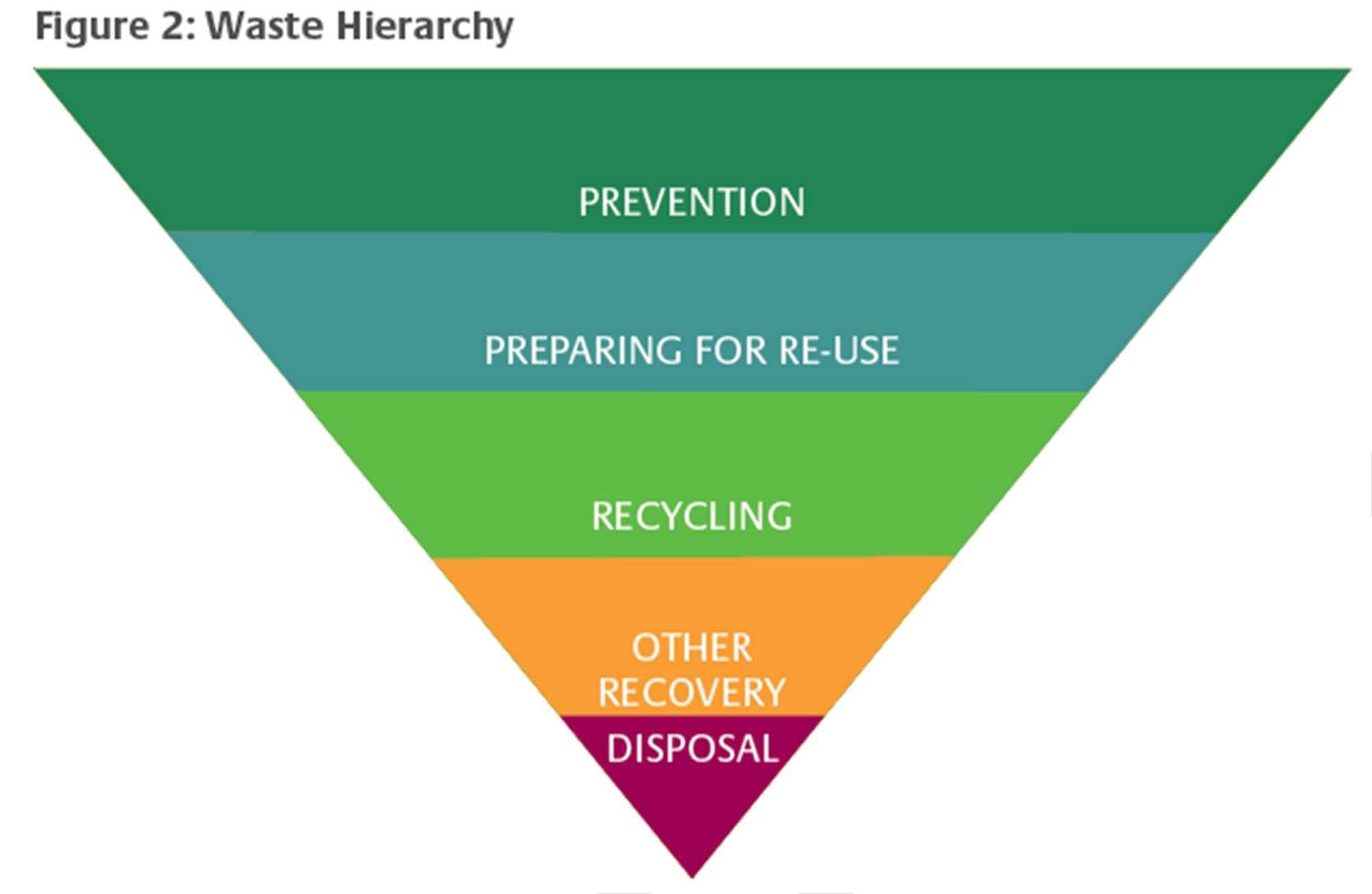
3.123 To minimise waste and pollution, and to reduce the impact of waste on climate change, we expect future developments to support the application of the waste hierarchy (Figure 2).
3.124 Given the pressing urgency of climate change and the need to embed the principles of the circular economy into all areas of our society, we encourage developers to consider including community spaces that help reduce waste and build community cohesion through assets such as community fridges, space for sharing, refill stations, and space for local food growing etc.
3.125 In order to facilitate the sustainable management of waste in the future it is essential that all developments provide adequate facilities for the separation of waste and recyclables and for its satisfactory storage prior to collection. On-site facilities for separating or storing waste should be adequate to meet the needs of occupiers of any proposed new development. Such facilities should be well-designed so that they do not result in harm to the local environment, for example in terms of amenity or local character.
3.126 Specifications for the minimum standards for the type and scale of facilities and vehicular manoeuvrability needed for new commercial and mixed-use developments will be informed by the ADEPT report ‘Making Space for Waste’ (June 2010). All applications will be assessed against this guidance. Residential development should be designed in accordance with Cherwell District Council’s Planning and Waste Management Design Advice. Bin storage areas must be able to accommodate the correct number of mixed recycling, refuse and food recycling bins; be safe and easy to use for residents and waste collection crews and meet the requirements of the waste collection authority.
Policy CSD 21: Waste Collection and Recycling
Development will be expected to incorporate suitable facilities to allow occupiers to separate and store waste for recycling and recovery unless existing provision is adequate. Such facilities should be well designed having regard to published guidance including (but not limited to) ADEPT ‘Making Space for Waste’ Designing Waste Management in New Developments: A Practical Guide for Developers and Local Authorities (2010).
The Council will support residential, commercial and mixed-use development proposals that:
i. Provide suitable internal storage space within their premises to enable the occupiers to separate, store and recycle their waste;
ii. Provide suitable, secure, external or communal storage facilities on site that allow for the separate storage and collection of waste, reusable items, recyclable materials and compostable waste;
iii. Include on-site waste management, which minimises the need for waste transfer, where it is feasible to do so;
iv. Allow for convenient and safe access to manage waste, including for older persons or persons with disabilities;
v. Allow for convenient and safe access for waste collection services;
vi. Demonstrate that bin storage, whilst being designed to meet practical needs, is integrated into the built form and does not detract from the overall design of the scheme or the surrounding area;
vii. Demonstrate that external bin storage is designed as an integral part of the overall design or are positioned to minimise the adverse visual impact;
viii. Enable waste from mixed-use schemes to be segregated in separate secured areas;
ix. Provide innovative solutions to reduce waste at source, and
x. All major development must be accompanied by a Waste Management Plan which demonstrates how the criteria set out above will be achieved.
Policy CSD 22: Sustainable Transport and Connectivity Improvements
3.127 One of our key objectives for meeting the challenge of climate change is to ensure that housing and employment are located within sustainable locations. Encouraging sustainable transport modes, low-carbon technologies, and living closer to jobs, education, services and amenities can lead to reduced travel, reduced carbon emissions and generally more sustainable communities.
3.128 We have described earlier the benefits of Oxfordshire’s and more specifically, Cherwell’s good strategic, local and public transport connections. However, Oxfordshire also experiences severe congestion in many places. Transport is the largest contributor to carbon emissions in the County, with 46% originating from road transport tailpipe emissions. The presence of the M40 and A34 is a key determinant in Cherwell and likely to be worse due to the high numbers of people who live in rural areas who rely more heavily on car usage.
3.129 Traffic congestion is a major cost to the local economy and has the potential to constrain future growth. If traffic growth continues due to an overreliance on the private car, many more of the district’s urban and interurban routes will become increasingly congested.
3.130 Since our last Local Plan there has been investment and improvements to our local rail infrastructure in Cherwell. This has included:
- A direct link from Oxford to Bicester via a new railway station at Oxford Parkway which includes a Park and Ride
- A new railway station at Islip
- Improvements to Bicester Village Railway Station
- Faster services from Banbury and Bicester to Oxford and London Marylebone.
3.131 Over the period to 2042, further improvements are planned to East-West Rail between Oxford and Milton Keynes, in particular, re-opening passenger services between Bicester and Bletchley, thus opening up this east-west corridor between Oxford and Cambridge. As well as passengers, our railways carry significant amounts of freight. There is an expectation that over the life of the plan some freight will be transferred to rail, and rail investments such as those identified in the Oxfordshire Rail Corridor Study (2021) could help support a shift of freight movements to rail.
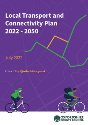
3.132 The County Council’s Local Transport and Connectivity Plan 2022-2050 (LTCP) sets out the transport strategy for the county. In addition, three initial supporting strategies for freight and logistics, active travel, and innovation were produced in 2021 and more are in production. The LTCP outlines a clear vision to deliver an inclusive and safe net-zero Oxfordshire transport system that enables all parts of the county to thrive, while also protecting the environment and making Oxfordshire a better place to live for all residents. It proposes to achieve this by reducing the need to travel, discouraging individual private vehicle journeys and making walking, cycling, public and shared transport the natural first choice.
3.133 Substantial investment and funding will be required to support net-zero carbon growth in Cherwell and across Oxfordshire. Our updated Infrastructure Delivery Plan sets out how we intend to secure investment from the government, transport operators, the development industry and other sources.
Improved Sustainable Transport and Connections
3.134 Making a difference to current travel patterns will require quality infrastructure for sustainable travel modes to make them our first choice. Proposals will therefore be required to plan for improved walking, cycling and public transport and provide these at an early stage of the development.
3.135 We will seek better connectivity, quality, accessibility and capacity of public transport and active travel. Our main transport corridors and facilities will need upgrading to enable efficient use of public transport and safe walking and cycling routes. We will work in partnership with Oxfordshire County Council, National Highways, Network Rail, and other providers to bring forward improvements to infrastructure, services and freight movements. Development should support and enable these projects, where appropriate.
3.136 The County Council's Mobility Hub Strategy and Central Oxfordshire Travel Plan (July 2023) set out strategies to address challenges related to improving multi-modal travel and better integrating different transport modes.
3.137 We will apply 20-minute neighbourhood principles as well as a ‘Healthy Streets Approach’ to development and infrastructure provision to facilitate trips by walking and cycling alongside reducing health inequalities.
Policy CSD 22: Sustainable Transport and Connectivity Improvements
The Council will support measures identified in the Oxfordshire Local Transport and Connectivity Plan and the area travel plans that support delivery of the Local Plan. We will work with Oxfordshire County Council to ensure that transport improvements contribute positively to the attractiveness and safety of our places, quality of life in Cherwell, and respond sensitively to our natural and historic environment.
Area strategy policies for Bicester, Banbury, Kidlington and Heyford Park and the Infrastructure Delivery Plan identify specific schemes addressing sustainable transport and connectivity.
All development should take a ‘decide and provide’ approach to manage travel demand by reducing the need to travel, planning for sustainable travel modes, and providing for zero emission vehicle use. Development is expected to follow the transport hierarchy set out below.
The Council will give priority to the movement of people according to the following hierarchy and this should be reflected in development proposals and infrastructure provision:
i. walking and wheeling (running, mobility aids, wheelchairs, and mobility scooters);
ii. cycling and riding (bicycles, non-standard cycles, e-bikes, cargo bikes, e-scooters and horse riding);
iii. public transport (bus, scheduled coach, rail, and taxis);
iv. motorcycles;
v. shared vehicles (car clubs and carpooling), and
vi. other motorised modes (cars, vans, and lorries).
All strategic developments will be expected to provide direct bus access, rapid electric charging points, car and electric vehicle community sharing clubs and mobility hubs in accessible locations, preferably close to public services/amenities on site.
Cycle, motorcycle and car parking provision, including electric charging points and storage, in new development should be made in line with Oxfordshire County Council parking standards and street design guidance and, where relevant, the Area strategies for Cherwell’s Places and Neighbourhood Plan policies.
Policy CSD 23: Assessing Transport Impact/Decide and Provide
3.138 This Plan seeks to increase the attraction of and opportunities for public transport. It has a strong focus on reducing the need to travel by private car and encouraging use of other modes of transport (travel choices), especially for shorter trips. It is important that new development can be accessed safely and that, to help manage car use, development is accessible by means of transport other than the private car. We will expect large-scale sites to provide access for public transport vehicles.
3.139 Proposals will need to quantify the likely transport impacts that they will have and describe any mitigation measures to reduce them. Proposals that will generate significant amounts of transport movements will need to be accompanied by a transport assessment, and a travel plan.
3.140 Further details can be found in Oxfordshire County Council’s ‘Decide and Provide’: Requirements for Transport Assessments (September 2022). To enable National Highways to establish the effectiveness of the decide and provide approach, transport assessments for large scale development should also be supported by a ‘worst case’ impact scenario’.
3.141 Measures in the Central Oxfordshire Travel Plan such as Controlled Parking Zones will be considered in the proximity of Oxford and transport/mobility hubs.
3.142 The requirement for travel plans is essential to encourage residents and employees to make use of sustainable transport networks, and to inform them of the travel choices available. A key element of this is the marketing of public transport, cycling and walking.
3.143 We will seek infrastructure for electric and low emission vehicles where appropriate and viable, with reference to the Oxfordshire EV Infrastructure Strategy.
Policy CSD 23: Assessing Transport Impact/Decide and Provide
The Plan supports Oxfordshire’s Local Transport and Connectivity Plan ‘decide and provide’ approach to help the delivery of public transport and active travel improvements as well as to manage the County’s road network in a manner which improves safety as well as reduces traffic and congestion.
Development that generates a significant number of trips will be required to be located in an area with an appropriate level of public transport accessibility and where public transport capacity and frequency can accommodate the proposed increase in the number of trips, or where capacity and frequency can be increased to an appropriate level through developer contributions, or other infrastructure funding.
These developments will be required to submit a Transport Assessment or a Transport Statement and where relevant a Travel Plan. Transport Assessments should follow latest guidance from Oxfordshire County Council and be supported by a ‘worst case’ traffic impact scenario that includes all development in this Local Plan.
Development proposals should:
i. Contribute towards the improvement of public transport and the improvement and delivery of walking and cycling routes that serve the site. This could be achieved through the design of development and/or through financial contributions appropriate to the scale and impact of the development;
ii. Be expected to provide, or make a proportionate contribution to the provision of, new and/or improved public transport infrastructure and services considering cumulative impacts of other approved developments in the area;
iii. Limit motor vehicle trips and identify and deliver highway safety measures at and around the development site, including temporary measures during the construction phase. This measure should reduce road danger and facilitate safer movements for all users and transport modes;
iv. Comply with the latest Oxfordshire guidance on design, cycle and car parking provision, servicing facilities and electric charging infrastructure.
Development which improves or provides new public transport infrastructure and facilities will be supported subject to:
v. Being acceptable in terms of impact on the environment including townscape, public realm and amenity of adjoining areas;
vi. Being designed to be safe, convenient, attractive and accessible for use especially for people with disabilities and specific mobility needs, and
vii. Providing adequate cycle parking and safe and suitable access on foot and by bicycle, including consideration of pedestrian and cycle desire lines.
Policy CSD 24: Freight
3.144 There is a need to better manage the movement of goods, both in rural and more urban areas. For example, there is a huge rise in online shopping, requiring goods to be transported quickly and in tight timescales. This presents a challenge for delivery services and can require running more vehicles to meet demand, especially Heavy Goods Vehicles (HGV) and Light Goods Vehicles (LGV). It is forecasted that freight miles will increase, which could lead to carbon dioxide emissions from freight transport increasing by around 20% by 2050 (Oxfordshire LTCP Baseline 2022).
3.145 Oxfordshire County Council has published Freight and Logistics Strategy (July 2022), in support of the Local Transport and Connectivity Plan, which sets out a strategy relating to the movement of goods on the road network. This Strategy Includes an HGV route map showing countywide appropriate and suitable routes.
3.146 The Council will work with partners to minimise freight trips on the road network and promote safe, clean and efficient freight movements where they are consistent with the delivery of the Local Plan.
Policy CSD 24: Freight
Local delivery hubs that reduce traffic will be supported particularly where it would lead to a reduction in noise and emissions from local freight trips and enable sustainable last-mile movements.
Policy CSD 25: The Effective and Efficient Use of Land – Brownfield Land and Housing Density
3.147. The NPPF requires that planning policies should promote an effective use of land in meeting the need for homes and other uses and include minimum density standards. Managing the use of previously developed land is important in minimising the use of greenfield land, maintaining the appearance of our towns and villages and in assisting the wellbeing of our communities. It can also provide opportunities for enhancing biodiversity. This means ensuring that land is not underused and that we make the most of vacant and derelict land and buildings.
3.148. We will support the redevelopment of previously developed land within the built areas of our towns and villages wherever possible. We will strive to ensure that any identified ‘brownfield’ regeneration sites are brought forward. The Council produces a Brownfield Land Register that identifies sites the Council considers to be suitable, available and achievable for residential development. It contains previously developed sites across the district with planning permission as well as sites without. We will continue to update and take into account its Brownfield Land Register in considering whether to identify land for new homes on previously developed land.
3.149. All housing development in Cherwell will be expected to make effective and efficient use of land. All new housing development should therefore be provided at a net density of at least 35 dwellings per hectare. Within our existing towns and Heyford Park higher densities will normally be required. However, the density of housing development will be expected to reflect the character and appearance of individual localities and development principles that are appropriate to the individual circumstances of sites.
Policy CSD 25: The Effective and Efficient Use of Land – Brownfield Land and Housing Density
All development will be required to make effective and efficient use of land which is to be utilised for buildings. Development should not utilise undeveloped land unnecessarily. Good design will be required to ensure this. Where there are significant concerns about the unnecessary use of land, a design review panel paid for by the applicant may be sought.
The Council will encourage the re-use of previously developed land in sustainable locations.
For residential development the following minimum densities (net) will be required unless specific local circumstances indicate that this would have an adverse effect on the character of the area, highway safety or the amenity of neighbours.
- 45 dwellings/hectare within existing settlements of Banbury, Bicester, Kidlington, and Heyford Park
- 40 dwellings/hectare urban extensions (less than 50 hectares)
- 35 dwellings/hectare urban extensions (more than 50 hectares)
- 35 dwellings/hectare rural and other areas.
Higher densities will be sought in locations where it will result in the optimum use of land, where there is good access to services and public transport, and where it would contribute to enhancing the character and legibility of a place.
A contextual design-led approach is encouraged.